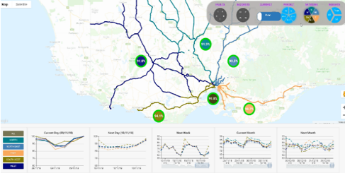
This project was delivered with the purpose of identifying V-line’s route punctuality and reliability; The data used in this project is visualized on Google map via the Google Maps JavaScript API.
The data included: a) Route data in GPS format, consisting of route segments starting from one location to another, b) Maker info, including type, GPS data, to represent different facilities and c) additional info attached to any route or makers to be shown when focused or clicked. The platform offered as well analytical graphics with regards to the performance of each route.
Outcomes
- Integrated platform for v-line performance measurement
- Line punctuality – historical and real-time
- IPredicted punctuality for next day, week, month, etc
Contact